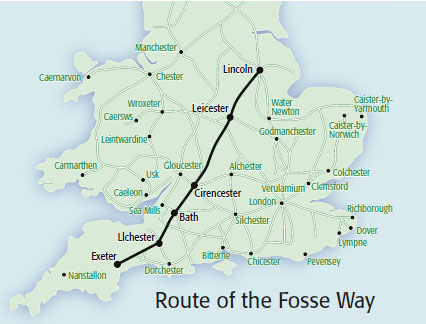
Laying out the road's line would have been relatively easy given clear countryside, once they know which way to go, but much of Britain was still heavily forested at the time. So the difficulty would be working through the woods when all you see is the trees.
I think they did have wheeled carts, but single-axle. Otherwise they would have used pack-animals.
Although military purposes were first and foremost, the Romans and Romano-British would have used the roads for commerce and civilian "traffic" too.
'
Ilchester is near Yeovil, about half-way between Bath and Dorchester, and marked the junction between two roads: the Fosse Way's continuation to Exeter, and the road to Dorchester, thence South to Weymouth. The Roman port is thought to have been up-river at Radipole, at least for small vessels, about 3 miles from the estuary.
To join Aqvae Svlis to Lindinis (Ilchester) means climbing over Eastern Mendip and a smaller but quite sharp ridge, giving the surveyors long views ahead; but then crossing a wide plain, an inland continuation of the Somerset Levels, to the fort and village established by the Romans on that plain's Southern fringe. West is more plain for some distance then the country becomes mainly hills, but I don't know how the Romans dealt with those. South reaches Dorchester by going over the Dorset Downs (along now, the A37).
The A354 from Dorchester goes over the Ridgeway escarpment, and the Romans' steep direct line is now just a track. The modern road deviated via a hairpin-bend, supplanted in turn in 2012 by a new road through a big cutting that might have been deeper and less steep if the LSWR or GWR had not got there first and put a railway tunnel though the hill.
So several land-forms for the Romans to cross, with a lot of forest cover and some very moist areas that might have been rich in willow woodland.
'
What is notable is how the post-Roman to modern roads sometimes deviate abruptly from their Latinate guides, even where the latter is still evident and the deviation has no obvious topographical advantage.
An example is on the A37, coming South from Shepton Mallet. A couple of miles from Ilchester bypass, the road turns very sharply right then wiggles round a bit before regaining the proper Via Lindinis; which runs straight on from the first bend, as a farm track. A second, modern deviation thanks to the bypass makes the original pop out in the village as a surfaced but "No Through Road" lane.
Hopper.


